Modeling Crime
March 13, 2013
First, an aside about the title. How do you spell "modeling?" In
high school, many decades ago, I was taught that you should double the final
l before adding
ing . Queries to the
Internet oracle known as
Google reveal that 90,100,000 web sites conform to this propriety, while more than twice that number (226,000,000) prefer to write "modeling" with a single
l. I guess it saves a little on
printing ink and
data transmission costs.
Wikipedia is ambivalent, preferring neither
one nor
the other.
Since
computers have facilitated
scientific modeling in all the
"hard" sciences,
computer modeling is being applied also to the
social sciences. I mentioned one such model in a
previous article (Numb3rs, June 6, 2012). There have been three recent published examples of modeling as applied to
crime in
Los Angeles,[1-2]
Boston[3-4] and
London.[5-7]
The Los Angeles study, which involved the use of
police department records to correlate social and geographical information with
gang membership in the
Hollenbeck policing district, was conducted by
mathematicians at the
University of California, Los Angeles,
criminologists at the
University of California, Irvine, and other scientists at
California State University, Long Beach and
Yale University.[2]
The essential idea of the model is that gang membership can be inferred from a person's geographic location and the people with whom he associates. Study data were obtained from Police Department Field Interview cards, which document
police stops of known or suspected gang members. [1-2] Since the stops are generally nonviolent in nature, it's assumed that the people present desire to be in each other's company.[2]
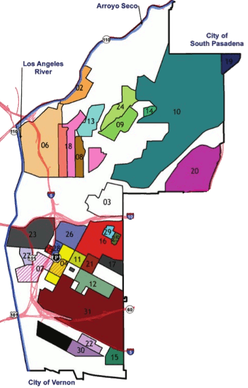
(Map of gang territories in the Hollenbeck area of Los Angeles. SIAM image, modified, by Matt Valasik and Blake Hunter.)
From these data, a
fully connected graph could be constructed for 748 individuals as nodes. The statistical technique, spectral clustering, was used to identify groups of similar behavior.[2] One interesting result is that clustering based on geographical location alone gave good results,[2] presumably since gang members favor their own territory and are persona non grata in the territories of most other gangs.
The study authors point out that the technique would be useful in other settings, including Afghanistan. In that case,
familial,
tribal and
religious affiliations can be used as source data.[2] Study coauthor,
George Tita, a
professor in the
School of Social Ecology at the University of California, Irvine, says
"The type of analysis undertaken in the paper can have practice applications for local law enforcement... While it certainly will not provide clues as to the particular individual that committed a gang-motivated crime, it can provide investigators a starting point with respect to the particular gang that might have been involved in the attack. Thus, the results of our analysis can provide a way for local police to allocate their scarce resources more strategically."[2]
This work was supported by the
National Science Foundation and the
Office of Naval Research.[2]
A computer modeling study of criminal violence in Boston was conducted by scientists from the
University of Michigan, Ann Arbor,
Rutgers University, the
Massachusetts Institute of Technology and
Harvard University.[3-4] The study looked at the relationship between
alcohol outlets,
drug markets (as inferred from
arrests for
drug possession and
trafficking), and violence in Boston for the year, 2006.[3] Fifty-five groups identified as being in the upper ten percent of violet crime were found to be poorer, have a greater numbers of alcohol outlets in their neighborhood, and higher rates of drug-related arrests.[3]
The study data were from
homicides, incidents of
aggravated assault, drug arrests and
"9-1-1" emergency calls, along with
demographic data from
state and
federal sources.[4] Drug possession arrests, rather than arrests for drug distribution, and density of alcohol outlets were themselves predictive of violent crime, but the study authors warn that other factors are involved.[3-4] Alcohol outlets included
liquor stores,
bars and
restaurants.[4]
This same study team is presently doing the same analysis for
Flint, Michigan, which has some of the highest violent crime rates in the US. This research was supported by a grant from the
National Institute on Alcohol Abuse and Alcoholism, a part of the
US National Institutes of Health.[4]
London and
England had a period of sustained
rioting, violence and
arson in the summer of 2011. These were the worst such events in more than twenty years, with many resulting injuries, five deaths, and extensive property damage, for an estimated cost of £250 million. A team from the
Department of Mathematics,
University College London, did a computer model of these riots.[5-6] Said study coauthor,
Toby P. Davies,
"A lot of previous research in this area has focused on the psychological and social motives of individual rioters, but our work is distinct from this, as instead of considering how and why the riots began, we take their initiation as our starting point and instead consider their development in terms of the city's layout over time."[7]
The model focused on three fundamental aspects of rioting; namely, their
contagious nature, the distances traveled by rioters; and the effect of police deterrence.[5] Rioting was cyclic, escalating during the day, peaking in the evening, and then calming post-midnight as police became involved. The time evolution of rioter involvement was similar to that of an
influenza outbreak and the spread of a
rumor or
meme on the Internet.[6]
Data showed that rioters typically traveled as far to riot as they would to shop. Also, the interaction between rioters and police appeared to follow the same rules as
predator-prey interaction, a
Lotka-Volterra model of
population dynamics. The idea here is that the rioters want to evade arrest, while the police want to reduce the number of rioters.[6]
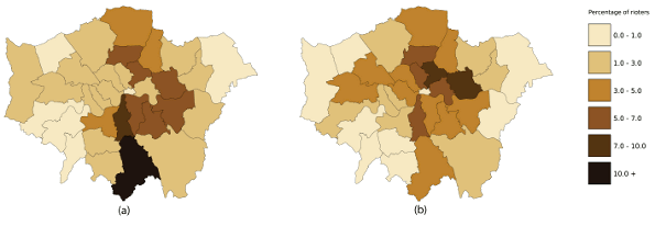
Model agreement is in the eye of the beholder. London rioter actual locations (a) and the model predictions (b). The study authors claim reasonable agreement for 26 of 33 boroughs, defined as being within one band of the prediction. (Figure 2 of ref. 5, Creative Commons Licensed image.[5]
References:
- Yves van Gennip, Blake Hunter, Raymond Ahn, Peter Elliott, Kyle Luh, Megan Halvorson, Shannon Reid, Matthew Valasik, James Wo, George E. Tita, Andrea L. Bertozzi and P. Jeffrey Brantingham, "Community Detection Using Spectral Clustering on Sparse Geosocial Data," SIAM Journal on Applied Mathematics, vol. 73, no. 1 (Online January 14, 2013), pp. 67-83. A PDF file of this paper is available until May, 14, 2013, here.
- Math helps detect gang-related crime and better allocate police resources, SIAM Press Release, February 14, 2013.
- Robert Lipton, Xiaowen Yang, Anthony A. Braga, Jason Goldstick, Manya Newton and Melissa Rura, "The Geography of Violence, Alcohol Outlets, and Drug Arrests in Boston," American Journal of Public Health, Online before Print, February 14, 2013, doi: 10.2105/AJPH.2012.300927
- Could a computer on the police beat prevent violence? University of Michigan Press Release, February 18, 2013.
- Toby P. Davies, Hannah M. Fry, Alan G. Wilson and Steven R. Bishop, "A mathematical model of the London riots and their policing," Nature Scientific Reports, vol. 3, Article no. 1303 (21 February 21, 2013), doi:10.1038/srep01303.
- Hannah Fry, "The London riots of 2011," hannahfry.co.uk, February 21, 2013.
- City layout key to predicting riots, University College London Press Release, February 21, 2013.
Permanent Link to this article
Linked Keywords: High school; Internet; oracle; Google Search; printing ink; data transmission; Wikipedia; scientific modelling; modeling; computer; hard science; soft science; computer modeling; social science; crime; Los Angeles; Boston; London; police; gang membership; Hollenbeck policing district; mathematician; University of California, Los Angeles; criminologist; University of California, Irvine; California State University, Long Beach; Yale University; Terry stop; police stop; fully connected graph; vertex; node; statistics; statistical; spectral clustering; persona non grata; Afghanistan; family; familial; tribe; tribal; religion; religious; George Tita; professor; School of Social Ecology; National Science Foundation; Office of Naval Research; University of Michigan, Ann Arbor; Rutgers University; Massachusetts Institute of Technology; Harvard University; alcohol outlet; illegal drug trade; drug market; arrest; drug possession; trafficking; homicide; aggravated assault; "9-1-1" emergency call; demographics; demographic; state; federal government of the United States; liquor store; bar; restaurant; Flint, Michigan; National Institute on Alcohol Abuse and Alcoholism; US National Institutes of Health; England; riot; rioting; arson; Department of Mathematics; University College London; Toby P. Davies; contagious; influenza outbreak; rumor; meme; predator-prey interaction; Lotka-Volterra model; population dynamics; borough; Creative Commons License.